September 3, 2007
We are in Kansas Dorothy! And boy is it flat.
OK, here are the subject lines if I had written an e-mail every day.
Friday: I am so stupid, stupid, stupid
Saturday: This is absolutely mind blowing
Sunday: I just want to get home
Monday: This is a small world/what does it mean
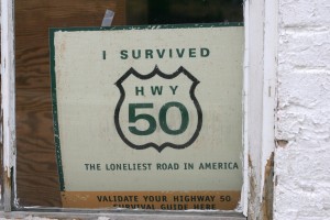
Let me explain. On Friday I continued to drive on the loneliest highway in the US, hwy 50, to Utah.

Highway 50 looking east towards the Snake Range, Humboldt-Toiyabe National Forest
East of Ely the mountain ranges changed. They used to run mostly parallel to the highway, but now they ran perpendicular to the highway. Once I drove thru one, a valley opened up and the next range was just a few miles away. Amazing, you just can’t get bored with stuff like that.
Once again I was hunting down a ghost town. What a disappointment. Luckily, it was not as creepy as the last one. I would not call this place a town. All that was left were some mining shafts and the usual rotten car. All that after driving up a mountain for a few miles on a dirt road at 10-15 mph.

Ghost Town – old mining hoist
I did make it into Utah. I can’t remember exactly how the mountains changed, but they did. Might have been the color or the shape, it seems so long ago. I think the mountains moved further away. There is really not much going on along this highway, towns are tiny and it comes as a surprise when they are bigger, like Delta. All of a sudden there were trees alongside the road, hadn’t seen those in a couple of days. The trees changed into a little green oasis and morphed into cultivated fields.

Fishlake National Forest north of Holden.
At the beginning of the day I had thought I make it to the KOA in Green River, near Moab and Arches National Park. Later in the day I had settled for Richfield, about 100 miles west of Green River. Highway 50 merges with interstate 70 soon after Delta all the way to Grand Junction, Colorado. I asked a lady at a gas station in Delta when the sun sets; at around 8:30 – 9 PM. It was only 7 PM and according to the guy at the KOA in Green River it would only take two hours from where I was to Green River. If I get to Green River that evening, I could photograph the arches in good morning light. If I stay in Richfield, I would get to the arches by noon and the light would be very harsh. What do I have to lose, it’s only interstate driving. Nothing ever happens on the interstate, it’s boring. At most I would be driving for ½ in the dark, not bad. Well, this is where the “I am stupid” comes in. Not too long after I got on I-70 I realized that this was not your usual stretch of interstate. By 8 PM! It was dark and all I could see were silhouettes of some mighty big mountains. Turnouts were marked as “Devil’s Canyon”, “Ghost Rock”. I couldn’t turn around, there were only few exits and I was too far along. I made a mistake! I could kick myself. I made it to the campsite by 9 PM. Setting up tent in the dark is a piece of cake, especially with a headlight.
San Rafael Reef, off exit 149 of I-70
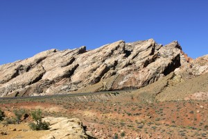
Saturday morning I was debating for some time if I should drive back and see what I had missed. I stopped by the visitor center and decided to drive back 50 miles and than drive on to see the arches. I set a new record; it took me four hours to drive the 50 miles going back west! That’s how much there was to see and I didn’t miss a turnout to take pictures. Going back east took only one hour. This area is absolutely mind blowing, amazing, unbelievable, fascinating, did I mention mind blowing? Only Mother Nature can create something this beautiful. The mountains were white with red, yellow, green, round or rugged, some looked wind blown in one direction, just unbelievable. Never mind the canyons. Great area for hiking and rock climbing. I am sooooooo glad I went back.

I-70 east bound thru the San Rafael Reef.
East of Green River, the mountains got smaller, more like big sand piles with little bushes. I turned south to go to the Arches National Park. Without much notice, the earth turned red and the mountains and rocks were deep red. The sunlight was perfect afternoon light when I got to the park. I had little more than 3 hours until sunset. I picked up a map and brochure at the visitor center. The brochure indicated which areas would be best photographed in the morning or afternoon, very helpful. Unfortunately, some of the arches could only be reached on foot. Two hour round trip hike, considered strenuous. It was 95F/35C and I was not up to the challenge. So I did the car thing, stopped where possible and walked in some cases. I
Horseshoe Bend, detail, in the San Rafael Swell north of I-70 west of exit 131.
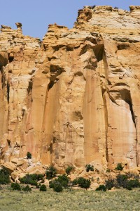
would like to come back to this place and spend more time exploring. Some of the rocks looked perfectly round, others looked like skinny walls. Do you remember making sand castles at the beach out of very wet sand? Letting the sand drip through your fingers. Some of the rocks looked like that. If you didn’t make those sand castles, cow manure drops in a similar fashion. All of the rocks, pinnacles and mountains were really, really red. I had only enough time to see one of the arches and a place called Windows. Rocks with giant holes. Unfortunately, there were again those people around. Luckily, not anywhere as bad as in Yellowstone.

Eagle Canyon – San Rafael Swell, I-70 exit 116.
Spent the night at the KOA in Moab. What a lousy night it was, couldn’t fall asleep and than woke up at 3 AM with the wind howling. The tent held up well, but when you are laying there and the wind is pressing against the walls of the tent you feel a little vulnerable. It was otherwise a beautiful night, the noon shone brightly, the stars were out in full force and it was warm, even at 3 AM.
Well, the next morning I was dead tired, coffee helped only moderately. I decided against seeing anymore of the sites in the area, would have been a waste on me. I headed for the Colorado border. After seeing so much amazing landscape, Colorado just couldn’t hold a candle to it or is it a light?

Arches National Park – Park Avenue
The mountains had moved closer to the road, no more wide open spaces. It is almost a blur to me, I was too tired and all I wanted was to get to a campsite and even more so, I want to get home! I remember a line of trees on top of a mountain ridge, looked kind of neat. The western part of Colorado was not anywhere as green and lush as I thought it would be. Still looked a little rugged. I had to drive over two major passes, one was around 7,000’ high and the other, Monarch Pass, measured over 11,000’. Coming down the first pass I looked down onto the Blue Mesa Reservoir, sunlight hitting the surrounding mountains, wow. No pullover possibility, no photo. The skies were gray and it rained from time to time. The drive along the Arkansas River was quite beautiful.

Arches National Park – Garden of Eden
That night I was asleep at 9:30 PM. Unfortunately, I woke up with a nasty headache. I had no interest in seeing much of anything. I was in Cañon City, known for its Supermax prison…
After an amazingly good breakfast, veggie omelet with fresh! veggies I drove towards the Kansas border. I will be taking highway 50 all the way east.
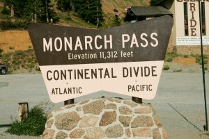
Monarch Pass, Continental Divide
The landscape started to flatten out, no more mountains and that even before I got to Kansas.

The old St. Cloud Hotel – Cañon City

Highway 50 sign – Kansas
This is a really small world. In Rocky Ford, Colorado I managed to get stuck in a ditch, nothing serious, but I knew I wouldn’t get out of it by myself. I walked to a farm stand around the corner and they pulled me out. We got talking and it turns out that a friend of the owner’s daughter went to New
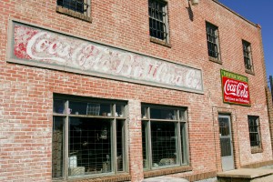
Old Coca Cola bottling building – Rocky Ford
York this summer to take ballet classes at the Joffrey Ballet School. She more than likely participated in the performance which I photographed. What are the odds?

Feed yard
Now I am in Dodge City, staying at the Holiday Motel. No camp grounds around. Not much happening in Kansas. Lots of feed yards around, not a pretty site and very smelly. This place is flat as a pancake.

Fields along highway 50 – Kansas
Here are a few stats. miles driven: 10,000, nights in a motel: 11, nights with friends: 13, nights camped: 20, oil changes: getting ready for the third.
Sorry, that this is such a long e-mail. I just had to get it all down before I forget even more.
I’ll be home soon,
P.S. Leaving Lawrence Kansas in a minute, had to pay credit cards first, thanks to Starbucks & T-mobile.